
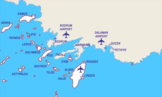
Rota TG1 - Marmaris - Yunan Adaları - Bodrum ( 1 hafta )
- Day 1 Marmaris - Kadirga
- Day 2 Kadirga - Rodos
- Day 3 Rodos - Simi
- Day 4 Simi - Datça - Kargi
- Day 5 Kargi - ince burun - Knidos - Mersincik
- Day 6 Mersincik - Alakisla - Orak island
- Day 7 Orak island - Akvaryum - Tavsanburnu
- Day 8 Tavsanburnu - Bodrum disembark
PLACES YOU CAN SEE IN THIS PROGRAM
Marmaris
As this quaint district, which is surrounded by green pine forests, was established directly over the ancient city of Phychos we do not have much information about the ancient site. However, from what we gather from a certain inscription, Phychos existed during the time of Alexander the Great, whereby the acropolis of this city was established one kilometer N of Marmaris on a low hill called Asartepe. Though it wasn’t long ago when there were visible remains of the ancient fortification wall, which was erected in the Classic and Hellenistic Periods, nothing can be seen of it today. After the death of Alexander, the Marmaris region was annexed to the Pergamon Kingdom, then it was captured by the Romans, Byzantines, the Mentese Beylik and then the Ottomans, respectively.
Among the few historical buildings found in Marmaris today, are a castle, which was built in 1557 and recently restored, a mosque in Kemeralti District, which was built by Mengelizade Ibrahim Aga in 1789 as well as a caravanserai which was constructed in 1545. This stone inn with brick vaults was erected on the road to Mugla during the reign of Süleyman the Magnificent in the military campaign against Rhodes. Located near the old junior high school is the Degirmen Brook Bridge, which was also erected during the time of Süleyman the Magnificent.
If you have the time, we recommend that you check out Sedir Adasi, as well as Karacasögüt, where you can see ancient theaters, temples and fortification walls. As you come out the bay, your boat will manuever past Keci Adasi and Yildiz Adasi, otherwise known as Nimara to call on Alkaya Cave. Then you will sail out to Kumlubük where to take a break of a couple of hours for lunch and an afternoon swim in the sea. Straight up from the pier are the Amos Ruins, which are situated on Asartepe.
With its styrax forest in the middle of the city, excursion trips taken with motorboats and its natural beauty, Marmaris is an ideal spot for rest and relaxation. In addition, the town, which is complimented with wonderful nearby bays such as Sedir Adasi, Karacasögüt, Mersincik, Hisarönü, is a paradise on earth.
Kadirga Burnu
Kadirga Burnu, where a lighthouse and a cottage for the lighthouse operators are situated. Kadirga Limani is right behind the cape. This is also known as ‘Çayagiz Koyu.’ There are submerged rocks in front of Kadirga Limani’s other cape. There are two inlets in the wide bay between the two capes. You can pitch your anchor overboard in the S inlet to a depth of 6 m. and tie your yacht to the shore. This location is closed off from all winds and exposed to the NW and B. You can navigate between the mainland and an island situated in front of the N cape of the bay. This is an ideal spot for those who like to swim.
Rhodes
Rhodes is the furthest south eastern island of Greece. it is a very popular, cosmopolitan island, where both Venetian and Turkish influence are apparent, giving it a special charm. Apart from the main harbour of Rhodes, where the magnificent statue of the Colossus once stood, you will find many picturesque, little coves, where you can swim in magical surroundings.
Mandraki
The main harbour of Rhodes. You cab tie on the N or the N end of the E quay. You will find the harbour can be fairly crowded and there is often four boats out from the quay. The harbour offers good shelter from prevailing winds. There is water and electricity available at the quay as well as fuel. All provisions can be found.
Lindos
You can moor where convenient in this large bay. The water is turquoise and offers an excellent area for a swim. Take the time to go ashore to visit the acropolis it is well worth the visit.
Symi
This rocky, mountainous island, north west of Rhodes, is one of the most beautiful of the Dodecanese. Here, mast of the inhabitants live off sponge diving. The main part is Gialos. Other interesting villages include Nimborios, Marthoundas, Pedi and Panormos. Enjoy swimming in the clear waters of Symi, but don't forget to taste the excellent wine, honey, almonds and olives produced here.
Datça
Datca, from which the peninsula derives its name, is a coastal district that possesses a jetty offering shelter from the wind. The jetty is on a peninsula that stretches towards the E, four nautical miles to the N of Ince Boron, which is marked on the chart with a lighthouse. This peninsula divides two bays, one to the N and the other to the 5, whereas the one to the S is protected by a breakwater which is positioned in the sea in a SE direction. There is a half-salt, half-freshwater lake adjacent to the district’s SW shore.
Knidos
Pulling out of Mersincik Limani and steering past Tekir Bükü, you will maneuver past lskandil Burnu to arrive in the small harbor of Knidos, which is the final bay along the Aegean seaboard. This was military harbor of Knidos, whereas the ancient geographer and historian Strabon from central Anatolia once wrote that 20 ships were able to moor here simultaneously. Warships once entered the harbor through a corridor to manuever past two round-shaped control towers at the narrowest spot. Please take note that the harbor on the N side of the isthmus is clogged with silt and with a draft of one meter is too shallow for even the smallest of boats. The actual harbor in use today is on the opposite side of the isthmus which is reached by navigating around Deveboynu Burnu. and its lighthouse, which can be seen as far as the entrance, The harbor entrance is 160 m. wide and one should approach the dock keeping clear of the ancient breakwaters. The one on the SW side is still in good condition, but the one in the NE side is submerged and can only be seen as a greenish-brown smudge under the water. Yachts can moor lines to the wooden jetties situated in front of the ancient city of Knidos. Draft in front of these jetties is down to 3.5 in., so you should be able to moor here without any trouble. In addition, you can easily drop anchor either in front of the theater inside the bay or else across from it. In addition to the ancient structures here, there is also a restaurant, an excavation bureau and storage facilities as well as a gendarmes station. The main harbor becomes unusable whenever severe gusts from the S and SE blow in. The road coming from Datça ends at the harbor. Moor your vessel in the main harbor of ancient Knidos and thoroughly enjoy the history and sea.
Mersincik
If you are sailing in from the N side of the Gulf of Gökova, Mersincik Limani is the final anchorage point after Körmen. It is 1.5 nautical miles SE of Mersincik Adasi. The bay is ringed with high mountains with woods, whereas the village of Mersincik is situated in the S point. Sailing past the N or S of Mersincik Adalari, you will enter Mersincik Limani, which is exposed to the NE. There is an anchorage spot right behind the cape to the W at the entrance. The draft at the entrance is 15 in., which drops to 4 m. by the time you reach the end of the harbor. Although the draft in front of the small pebbled beach is 6-10 in., the bottom is of loose sand, rendering this spot inappropriate for anchoring. However, the NE and SW parts of the shore are more suitable for dropping anchor. From here, let’s sail for the famous ancient city of Knidos.
Orak Island
One of the larger islands in the Gulf of Gökova is Orak Adasi, which lies in the approach to Kargicik Bükü. The name most probably comes from the fact that the end of the island resembles a sickle. Orak Adasi is located about five nautical miles E of Kara Ada and in front of Pabuc Burnu, whereas its W and N shores are spotless.
Also, a good place to drop anchor would be the bay located on the E side of the island, which is sheltered from N and W winds. There is a small islet situated in front of the bay. The bay can be entered by approaching from the N of the island and navigated past this small islet. Rocks surround the entire island as well as the bay. You can drop anchor in 4-5 m. of water and tie a mooring line around one of the rocks lining the shore of this bay, which is a decent anchorage spot. There is a small inlet located next to this bay which is also suitable for dropping anchor. These small inlets offer you some privacy whereas you can take a refreshing dip in the sea whenever your heart desires.
Yildiz Adasi is situated in front of Alakisla Bükü, which is situated three nautical miles NE of Orak Adasi. The seabed at Alakisla Bükü doesn’t hold anchor. Although a harsh meltem blows through this bay, which is exposed to the 5, it offers shelter against N and W winds.
Bodrum
Bodrum, the native homeland of the famous historian Herodotus, is one of Turkey’s most important tourism centers, which attracts attention by virtue of its natural beauty.
We know that the native inhabitants, namely the Lelegians and the Carians, lived in the hills above the Bodrum Peninsula. In fact, although there are very few remnants extant, it has been determined that a number of Lelegian cities such as Termera, Pedesa, Thangela, Syengela, Myndos and Telmissus existed above the peninsula. In the Iliad, Homer tells us that the Lelegians, who were under the command of Altes, as well as the Carians, under the command of Nartes fought on the side of the Trojans during the Trojan Wars of ca. 1200 B.C.
After the Turks entered Anatolia in 1071, they ater began establishing provinces in the regions they had settled. As a matter of fact, the Turks under command of Mentese Beytook over this region and the established the Mentese Province in 1274. This area was put under Ottoman rule once and for all during the reign of Sultan Suleyman the Magnificent
As we mentioned at the beginning of this chapter, not much remains to this day of Halicarnassos as it is buried under the modern town of Bodrum. The theater on the hill belongs to the Mausolos period. Excavation and restoration work of the theater has been carried out, whereby 30 rows of seating in the lower section were brought to light. On the S slope of the theater, the upper section of which is heavily damaged, you can encounter rock tombs belonging to the Hellenistic and Roman Periods. Ancient sources reveal that 1) the Temple of Mars and the stoa of Apollo are under the road in front of the theater. 2) the Temples of Hermes and Aphrodite were situated on both sides of Kaplankale, across from the castle and 3) there was the palace of King Mausolos where the mosque is located, in the square in front of the castle. Today, the Myndos Gate, which was a portion of the wall that once surrounded the city, can be seen on the road to Gumbet The castle, which has become the symbol of modern day Bodrum, was built by the Knights of Rhodes in the year 1402. It measures 180 x 185 m. and its first battlements were erected by German architect Heinrich Schlegolholt. Later on, the castle was reinforced with the Italian, French, English, German Towers as well as the Snake Tower. There are a total of 249 coat-of-arms found throughout the castle walls. The Turks captured it in 1 523, whereas today, it serves as the Bodrum Museum of Underwater Archaeology. In the adjacent garden, you are bound to encounter numerous peacocks which seemingly stand guard over the treasures, not terribly unlike their Beefeater counterparts at the Tower in London.
There are not many Turkish edifices in Bodrum. The famous Bodrum boats or gulet as they are known in Turkish were constructed during the Ottoman Period in a shipyard just beyond the yacht marina. Today, the manufacture of these fine wooden vessels continues in this area. There is the tomb of Kaptan-i Derya Kizilhisarli Mustafa Pasha and his son Cafer Pasha situated where this shipyard is located. There is also the mosque in the quay square that was built by Mustafa Pasha in 1720. The Pasha’s steward also had the Tepecik Mosque built. Erected in 1769, the Haci Molla Inn survives to this day. but not in its original fashion.
Bodrum is one of the traditional points of embarkment for Blue Voyagers whereas its many bars, cafes, clubs and restaurants offer countless opportunities for fun until the crack of dawn.
There are several sites of ruins around the Bodrum Peninsula. For example, you may visit the ancient city of Heracleia, which was established on top of a hill overlooking Bafa Gölü. There you will see the Temple of Athena, which was erected during the Hellenistic Age. Also, 12 km. outside of Milas, on the side of the road, you will encounter the Temple of Euromos Zeus with its 6 x 11 colonnade. It was erected during the Roman Age. Also, the Labranda Ruins, which are 13 km. outside Milas, are quite impressive as well. In addition, Iasos, which is situated in the village of Kiyikislacik is worth a visit.